
Trekking around Nanga Parbat: Routes, Seasons and Difficulty
Nanga Parbat (8,126 m) can be approached on foot from three sides, and the experience differs completely between them. Fairy Meadows on the north side is a short, hut-based trek that most fit walkers can manage; the Rupal valley on the south side leads to the foot of one of the tallest mountain walls on earth; and the Mazeno Pass links the two over a glaciated saddle of about 5,400 m that is a serious undertaking.
This guide explains how the routes fit together, which season suits each one, and how our published itineraries use them, so you can match the mountain to your experience and your time.
The mountain and its three faces
Nanga Parbat stands alone at the western end of the Himalaya, rising above the Indus where the river bends around it. It is the ninth-highest mountain in the world and the second-highest in Pakistan after K2. Because there are no comparable peaks around it, its height above the surrounding valleys is unusually dramatic, and you see it from far along the Karakoram Highway and from the Deosai plateau.
Trekkers usually describe the massif by its faces. The Rakhiot face looks north over Fairy Meadows and the Raikot glacier. The Diamir face looks west over the Diamir valley, the side from which many climbing expeditions attempt the summit. The Rupal face looks south over the Rupal valley near Astore and rises several thousand metres in one sweep, which is why it is so often called one of the highest mountain faces in the world.
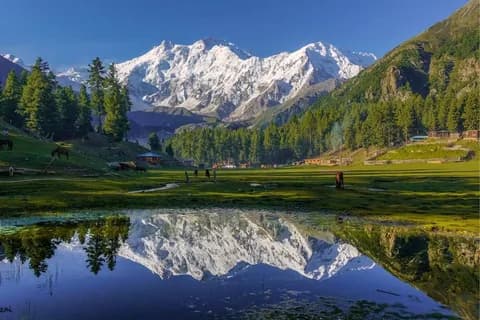
Route 1: Fairy Meadows and the Rakhiot side
The north side is the gentlest introduction to the mountain. In our Fairy Meadows Trek and Hunza Tour the group leaves the Karakoram Highway at Raikot Bridge, changes to local jeeps for the narrow track up to Tatto village, and walks the last stretch to Fairy Meadows, where nights are spent in huts rather than tents. A rest day allows short walks around the meadow, and a full day is set aside for the walk up the valley beside the Raikot glacier to Nanga Parbat base camp and back.
The highest point listed for that programme is about 3,300 m, and its published season runs from mid-May to the end of November, much longer than the high routes. The trek is combined with a few days in Hunza, so it suits travellers who want one mountain walk inside a broader tour. The Fairy Meadows destination guide covers the place itself in more detail.
What to expect on the jeep track
The jeep road from Raikot Bridge to Tatto is unpaved and exposed in places, and local drivers who know it well operate it. It can close after heavy rain or landslides, which is one reason itineraries in this region keep some slack in the schedule. If you are nervous about exposed roads, say so when you plan; it does not rule the trip out, but it helps to know what is coming.
Route 2: the Rupal valley from Astore
The south side is reached from Astore. Jeeps continue from Astore to Tarashing, the village at the mouth of the Rupal valley, and from there the trail crosses the Tarashing glacier into a valley of summer settlements, juniper and willow, with the Rupal face filling the head of the valley. This side feels more remote than Fairy Meadows and sees fewer visitors.
Our published Nanga Parbat Mazeno Pass Trek begins this way, walking via Bazin and Shaigiri along the moraine of the Rupal glacier. Our Deosai biking tour also visits Tarashing and, weather permitting, includes a walk towards the Rupal base camp before crossing towards the Deosai plateau. The Astore Valley guide describes the valley and Rama Meadows, which lie on the same side of the mountain.
Route 3: the Mazeno Pass crossing
The Mazeno Pass connects the Rupal side to the Loiba and Diamir side. In the published itinerary the group camps at Mazeno base camp, then at a high camp beside the Mazeno glacier, and crosses the pass early the next morning, listed at about 5,390 m, before descending to Upper Loiba and the Loiba meadows. The route then continues to Kachal and Diamir base camp, where the itinerary includes a rest day, before walking out to Hallal Bridge and returning to Chilas by jeep.
This is a glacier crossing at high altitude, with long days, nights in tents and limited options for turning back once you are committed. It suits trekkers who have already walked comfortably above 4,500 m and are at ease on rough moraine and snow. The programme's published season is June to the end of August, when snow conditions on the pass are most predictable, although no season removes the need for a weather decision on the day.
The routes side by side
| Programme | Days | Best time | Highest point | Tent nights |
|---|---|---|---|---|
| Fairy Meadows Trek & Hunza Tour | 12 | Mid-May to End of November | 3,300 m | 0 |
| Nanga parbat Mazeno Pass Trek | 17 | June to End-August | 5390 m | 11 |
| Deosai Biking Tours | 19 | — | — | 5 |
Figures are taken from the published itineraries; a dash means the programme does not state the value.
Choosing between them
Whichever side you choose, read our guide to altitude sickness on Pakistan treks before you go; even the short approach to base camp from Fairy Meadows climbs well above the meadow.
- Short on time, or new to trekking: Fairy Meadows. The walking is moderate, nights are in huts, and the season is long.
- Want solitude and the biggest view of the mountain: the Rupal valley. It is more remote and is usually combined with other parts of the Astore side.
- Experienced and looking for a real crossing: the Mazeno Pass. It needs fitness, altitude experience and a flexible attitude to weather.
- Prefer wheels to walking: the Deosai biking tour links Astore, Tarashing and the Deosai plateau, with the mountain in view for several days.
Practical points for the Nanga Parbat region
Getting there
All three routes start from the road. In our itineraries the group drives from Islamabad to Chilas over the Babusar Pass and continues from there, either to Raikot Bridge for Fairy Meadows or to Astore for the Rupal side. The Babusar road is a summer road; when it is closed, traffic uses the Karakoram Highway instead. Our guide to getting from Islamabad to the north explains the options.
Weather and timing
Nanga Parbat makes its own weather, and cloud often builds on the summit by midday, so the clearest views are usually early in the morning. Snow lingers late on the high routes, and the higher campsites can be cold even in July. Pack for sub-zero nights on the Mazeno route and for cool evenings even at Fairy Meadows.
Respecting the people who live here
Fairy Meadows, Tatto and the Rupal settlements are summer pastures and homes as well as trekking stops. Ask before photographing people, use the toilets and rubbish arrangements provided, and see our responsible travel guide for the customs that matter most in these valleys.
Frequently asked questions
Can a beginner trek to Nanga Parbat base camp?
On the north side, yes, if you are a reasonably fit walker. The walk from Fairy Meadows to the Rakhiot base camp and back is a long day but follows a clear valley trail. The Mazeno Pass is a different matter and is not a beginner's trek.
Do I need a permit to trek around Nanga Parbat?
Our published Fairy Meadows and Mazeno Pass programmes are listed in the open zone. Rules can change, so we confirm the current requirements when you plan; our guide to trekking permits and zones explains how the system works.
Where do you sleep at Fairy Meadows?
The Fairy Meadows programme lists nights in huts at Fairy Meadows. Facilities are simple and mountain-style, and they vary from season to season.
When is the best month for the Mazeno Pass?
The programme's published season is June to the end of August. Within that window, conditions on the pass depend on the year's snow and on the weather in the days before the crossing.
Can I see Nanga Parbat without trekking?
Yes. The mountain is visible from viewpoints along the Karakoram Highway near Raikot, from parts of the Astore road and from the Deosai plateau on clear days. Several of our tours pass these viewpoints.
Plan your Nanga Parbat trip
Tell us how much trekking you have done, how high you have slept before and how many days you have, and we will suggest the side of the mountain that fits. You can also browse all our routes on the trekking page or send your dates through the contact form.